
Welcome to Chattanooga
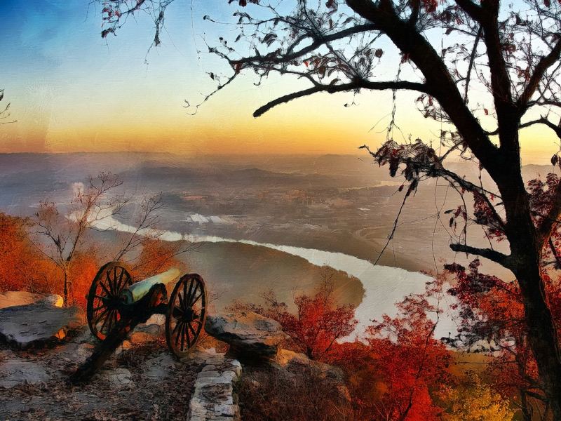
A cannon at Point Park overlooking the Tennessee River's Moccasin Bend and the city at sunrise

Outdoor Chattanooga

Get Outside. It's Kind of Our Thing.

Ridgelines above, a river through the middle, and greenways connecting it all — adventure starts minutes from downtown.

Chattanooga earned its Scenic City nickname honestly. Lookout Mountain, Signal Mountain, and Raccoon Mountain frame the city, and the Tennessee River winds right through it. You can bike a paved riverside greenway in the morning, hike to a cliffside sunset in the evening, and never be more than a short drive from downtown.

Featured

The Tennessee Riverwalk

Access points, parking, and family-friendly stretches.

Trails & activities

Find your next adventure

Distances and conditions change. Use each card's official link to check closures before you head out.

11 of 11 shown

The CHATTANOOGA lettering on the 21st Century Waterfront wall along the Riverwalk
easyWalkingRunningBiking

Tennessee Riverwalk

Chattanooga's signature greenway follows the south bank of the Tennessee River, linking downtown's riverfront parks with the Tennessee Riverpark and the Chickamauga Dam area, and connecting with the South Chickamauga Creek Greenway.

Distance
13 miAbout 13 miles of main path per TrailLink; some guides cite up to 16 miles depending on which segments are counted. Most visitors do a short out-and-back.
Time
Choose your distance — 30 minutes to a full day
Surface
Paved concrete
Trailhead
Ross's Landing (downtown)100 Riverfront Pkwy, Chattanooga, TN 37402
Parking
Paid parking downtown near Ross's Landing. Free lots at Tennessee Riverpark and several trailheads east of downtown (see access points).
Families
Family-friendly. Flat, paved, and stroller-friendly. Watch for cyclists.

Sections can close for maintenance or high water. Check with Hamilton County and the City of Chattanooga before a long ride.

moderateHikingBikingRunning

Stringer's Ridge

A forested ridge right above the Northshore with overlooks of downtown and the river, preserved through a citizen-led effort.

Distance
7 miAbout 7 miles of natural-surface trail across a 92-acre urban wilderness park.
Time
1–2 hours
Surface
Natural path
Trailhead
Spears Avenue Trailhead (main)1312 Spears Ave, Chattanooga, TN 37405
Parking
Main trailhead on Spears Ave has parking, restrooms, a bike repair station, and a pump track. Limited parking at the Bell Ave trailhead (787 W Bell Ave).
Families
Family-friendly. Shorter loops work for school-age kids; some climbs.
moderateHiking

Sunset Rock via the Bluff Trail

A sandstone ledge on the west face of Lookout Mountain with one of the area's best sunset views over Lookout Valley.

Distance
4 miRoughly 2 miles each way from Point Park on the Bluff Trail. A much shorter, rocky path leads down from the small West Brow Rd lot.
Time
2–3 hours from Point Park
Surface
Rocky, with stone stairs
Trailhead
West Brow Rd lot (Sunset Rock)405 W Brow Rd, Lookout Mountain, TN 37350
Parking
Very limited parking at West Brow Rd (about 10 spaces; the Park Service asks visitors not to park on the street or in yards). Paid parking at Point Park.
Families
Better for experienced adults. Sheer drop-offs — keep children close.

Cliff edges with no railings. Point Park charges an entrance fee — check NPS for the current amount and hours.

Cannon at Point Park overlooking Moccasin Bend at sunrise
easyWalking

Point Park Overlook

Civil War history and the classic view of Moccasin Bend and downtown from the top of Lookout Mountain. Open roughly 6 a.m. to sunset.

Distance
0.5 miShort paved and gravel paths inside the park.
Time
45–90 minutes
Surface
Paved and gravel
Trailhead
Point Park entrance110 Point Park Rd, Lookout Mountain, TN 37350
Parking
Paid parking near the park entrance. You can also ride the Incline Railway up and walk a few blocks.
Families
Family-friendly. Easy walking; supervise children near overlooks.

Entrance fee applies.

moderateHikingRunning

Lookout Mountain Bluff Trail

Hug the base of Lookout Mountain's upper cliffs past rock outcrops, springs, and views — with options to connect to Sunset Rock and Cravens House.

Distance
5 miAbout a 5-mile loop when combined with connecting trails; part of a 30+ mile trail network in the national military park.
Time
2.5–3.5 hours
Surface
Rocky natural path
Trailhead
Point Park110 Point Park Rd, Lookout Mountain, TN 37350
Parking
Paid parking at Point Park; limited parking at Cravens House and West Brow Rd.
Families
Better for experienced adults. Better for older kids and teens.

Check NPS alerts for trail closures before you go.

Some details are still being confirmed. Check the official source before you go.

easyHikingWalking

Reflection Riding Trails

Gardens, meadows, and forest at the base of Lookout Mountain, run by a nonprofit nature center. Access is open to all; donations are welcome.

Distance
10 miAbout 10 miles of trails on campus that connect to National Park land leading up Lookout Mountain.
Time
1–3 hours
Surface
Natural path and gravel
Trailhead
Reflection Riding main lot400 Garden Rd, Chattanooga, TN 37419
Parking
Check in at the main parking lot for a visitor pass. Do not block the gate.
Families
Family-friendly. Gentle meadow and creekside loops; native wildlife exhibits.
easyHikingBikingRunningWalking

Enterprise South Nature Park

A large wooded park northeast of downtown with trails for hikers, mountain bikers, and riders.

Distance
VariesPaved and natural-surface trails for hiking, biking, and horseback riding. Check the park map for current mileage.
Time
1–3 hours
Surface
Paved and natural
Trailhead
Main entrance190 Still Hollow Loop, Chattanooga, TN 37416
Parking
Parking at the visitor center and trailheads inside the park.
Families
Family-friendly. Paved loops are good for bikes and strollers.

Some details are still being confirmed. Check the official source before you go.

easyWalkingRunningBiking

South Chickamauga Creek Greenway

A creekside greenway through eastern Chattanooga and East Ridge with elevated boardwalks, overlooks, and a boat ramp.

Distance
12 miAbout 12 miles, connecting to the Tennessee Riverwalk at its northern end.
Time
1–4 hours
Surface
Paved, boardwalk, and some gravel
Trailhead
Amnicola Hwy connection3716 Amnicola Hwy, Chattanooga, TN 37406
Parking
All trailheads have free parking, per the City.
Families
Family-friendly. Boardwalks and interpretive signs; some rough sections.

Some sections are gravel and rough pavement.

easyWalkingBikingRunningHiking

Chickamauga Battlefield

Biking, walking, and scenic driving through Civil War history about 20 minutes south of downtown, in Georgia.

Distance
VariesPark roads and trails across the battlefield, part of the Chickamauga & Chattanooga National Military Park.
Time
1–3 hours
Surface
Paved roads and natural trails
Trailhead
Chickamauga Battlefield Visitor Center3370 Lafayette Rd, Fort Oglethorpe, GA 30742
Parking
Parking at the visitor center and pull-offs throughout the park.
Families
Family-friendly. Wide open fields and quiet park roads.

Some details are still being confirmed. Check the official source before you go.

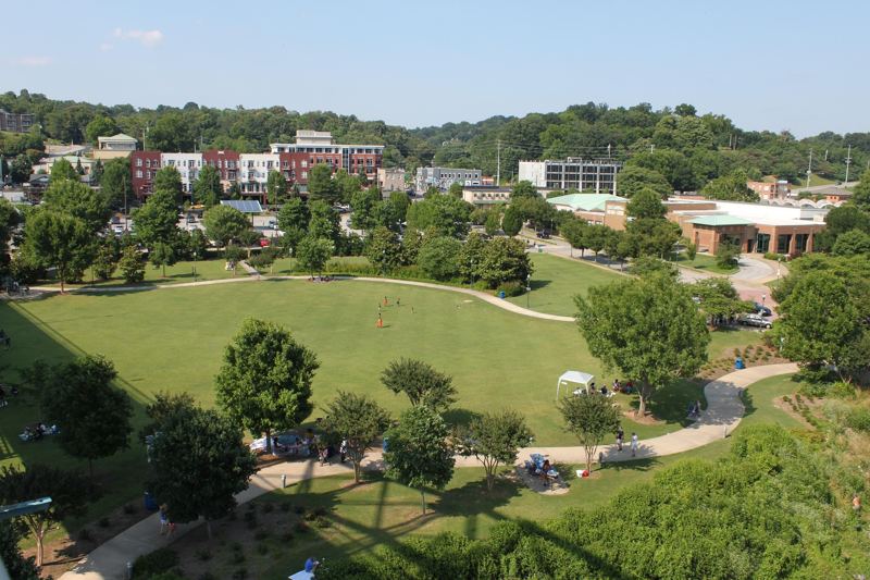
Coolidge Park's lawn and paths from above
easyWalkingRunning

Coolidge & Renaissance Parks

Easy riverside strolling with skyline views, connected to Downtown by the Walnut Street and Market Street bridges.

Distance
1 miAbout a mile of paved paths and boardwalk between the two Northshore riverfront parks.
Time
30–60 minutes
Surface
Paved and boardwalk
Trailhead
Coolidge Park150 River St, Chattanooga, TN 37405
Parking
Paid parking around Coolidge Park; or walk over the Walnut Street Bridge.
Families
Family-friendly. Stroller-friendly with a carousel at Coolidge Park.

Some details are still being confirmed. Check the official source before you go.

A rider jumping off a dock during a water sports event on the Tennessee River
moderateKayaking & Paddleboarding

Paddling the Tennessee River

Kayaking and paddleboarding past the downtown skyline is one of Chattanooga's most memorable views. First-timers should book with a local outfitter for gear, guidance, and current river conditions.

Distance
VariesDistance depends on your launch and take-out.
Time
Varies
Surface
Open river
Trailhead
Ross's Landing riverfront100 Riverfront Pkwy, Chattanooga, TN 37402
Parking
Paid parking downtown.
Families
Better for experienced adults. Kids should paddle with an experienced adult and a life jacket.

The river is shared with barges and boats, and current changes with dam releases. Always wear a life jacket and check conditions first.

Some details are still being confirmed. Check the official source before you go.